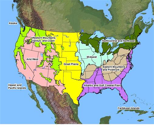
 Delineation manuals are designed to draw an artificial line dividing the wetness gradient into wetland and non-wetland zones. In August of 1991, the president signed the 1992 Energy and Water Development Appropriations Act in which Congress directed the Corps to use the 1987 Corps manual in the Section 404 permitting program. While this action standarized the method the Corps uses to delineate wetlands, concerns about regional differences in wetlands persisted. In 1995, the Natural Reseacrh Council, under funding from the Environmental Protection Agency, made several recommendations for improvement, including a call for improved sensitivity to regional differences in climate, hydrologic and geologic conditions and other wetland characteristics. Based on this recommendation, a new and consistent system of wetland delineation by regions was established. Regions are based on natural boundaries such as ecoregions or land resource regions, rather than political boundaries. In the Galveston District, we have two supplements to the 1987 Corps of Engineers Wetland Delineation Manual, the Great Plains Supplement and the Atlantic and Gulf Coast Plain Supplement.
| Title |
Description |
| 1987 Wetland Delineation Manual |
The official Corps' manual for determining and delineating wetlands. |
| Regional Supplement to the Corps of Engineers Wetland Delineation Manual: Atlantic and Gulf Coastal Plain Region Version 2.0 |
This supplement is applicable to the Atlantic and Gulf Coastal Plain Region, which consists of all or portions of the District of Columbia and 19 states: Alabama, Arkansas, Delaware, Florida, Georgia, Illinois, Kentucky, Louisiana, Maryland, Mississippi, Missouri, New Jersey, North Carolina, Oklahoma, Pennsylvania, South Carolina, Tennessee, Texas and Virginia. |
| Regional Supplement to the Corps of Engineers Wetland Delineation Manual: Great Plains Region (Version 2.0) |
This supplement is applicable to the Great Plains Region, which consists of all or significant portions of 11 states: Colorado, Kansas, Minnesota, Montana, Nebraska, New Mexico, North Dakota, Oklahoma, South Dakota, Texas and Wyoming. |